- Social Studies 5th Grade
Geography Unit: Midwest America
VA SOL NAG 5.5a The student will explore the Midwest region of the United States by locating the Midwest region on a map and identifying key political features - Additional SOLs: English 5.7f The students will write for a variety of purposes: to describe, to inform, to entertain, to explain, and to persuade.
Essential Question for the Year: How does geography impact the growth of a nation?
Essential Question for the Unit: What are the major Midwest contributions and lessons to our economy, history and technology?
Lesson 1: Where is the Midwest located and what are some features of the land there?
Objective: Students will be able to locate the Midwest on a map and describe major features of the states there, subcategorizing them into Great Plains and Great Lakes states.
Materials: Promethean Board with maps ready, map worksheets for students, preassessment, laptops, Harcourt Texts
Preassessment (5 minutes)
Give students a blank map and a colored pencil. Have them label which states they think belong in the “Midwest United States”.
Input (Knowledge and Comprehension) - Whole Group Lesson on the carpet (20 minutes)
Using a color-coded map on the Promethean Board, label with students which states are considered Midwest. See attached
Why would this state be considered a Midwest state? What does its geographic location tell you? Is geographic location the only component for categorizing states? What else do we know about these states that is relevant to their title of "Midwestern states"?
Make some predictions about states in the Midwest based on its location.
Are there any subgroups you would split the Midwest into?
Using new color-coded map on the smartboard, give students two labels “Great Plains States” and “Great Lakes States” and go through each state in the Midwest challenging students to identify which category each belongs in and give reasons why. See attached map
Questions: What does the geographic location have to do with which section of the Midwest the state is labeled?
What physical features of land or weather patterns do you think are common for these areas? How do you know?
Make some predictions or generalizations about the economy and main focuses of these states. Share
Fun Facts and Capitals – show students the picture of the nicknames and capitals of the Midwest and try to decide why that state might be called that. See Attached
What can we learn from looking at a state’s postcard? (show examples below) - Deconstruct postcard needs (picture(s)/phrase on one side). What information is included? Who is the audience? How is it appealing? What amount of creativity or cleverness is needed?
- PERSUASIVE WRITING - a postcard is meant to drive people to want to visit a certain place, people choose postcards appealing to the recipient, who would want to visit the state chosen and why?
Process Learning (Creative & Critical Thinking, Application, Analysis, Synthesis, Evaluation & MI) Cooperative Centers with laptops (30 Minutes)
Students will pair up or work independently (independent vs interactive learning choice) and choose a MW state to research: North Dakota, South Dakota, Nebraska, Kansas, Minnesota, Iowa, Missouri, Illinois, Wisconsin, Indiana, Michigan or Ohio. (Content differentiation) They may use the state's official .gov website or their textbooks to gather their information. Possible options include: the state’s nickname, its origin and whether the nickname is still applicable today. Other items to notice are the state capital, the state flag, the state flower, a common food in that state, landmarks or lifestyles associated with the state as well. Students should document their findings on a postcard created for that state which contains a picture and phrase on the front with descriptive information on the back that would persuade someone to come visit it.
Students will research using nonfiction textbook and internet resources in pairs, dividing up the workload to accomplish the assignment in 1 working center.
Students who finish early can write on the back of the postcard a friendly hello as if the postcard actually had a recipient. Don't forget a state friendly stamp!
Output (Products, Ideas, Problem-Solving & Research)
Assessment
- Observation and participation during lesson. Teacher will assess completion of postcards as well as accurate information included based on research and discussion of what should be included. Creativity and persuasiveness of the card to a specific audience in keeping the integrity of the theme of the state will also be considered.
Differentiation
- Students will build a creative connection with a particular state through the postcards.
- Visual learners will benefit from the color coding of the maps. Students who are unfamiliar with state names or with no pre-conceptual knowledge of the Midwest will have a chance to work with color coded maps and have opportunities to label them multiple times.
- Students have a choice of working independently or collaboratively.
- Content of which state and postcard contents will be chosen by the students.
- Keep in mind Student E lived in Michigan, Student A goes to Indiana every summer and use their knowledge and experience within lesson.
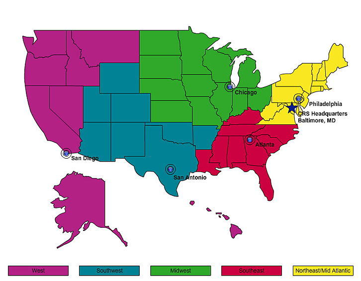
Map of Regions of US
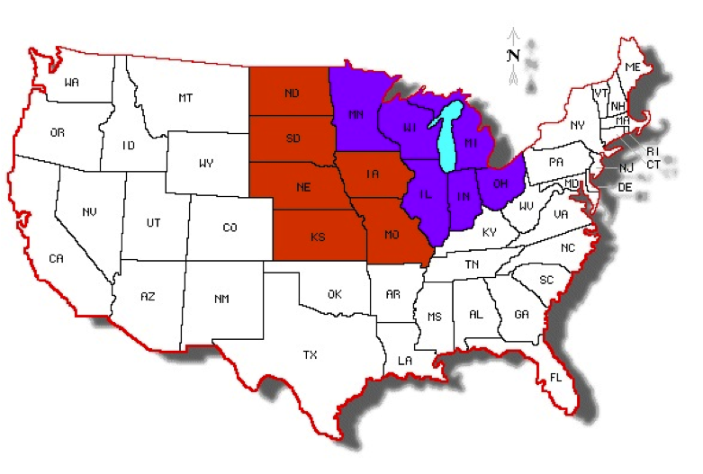
Map of Midwestern Regions
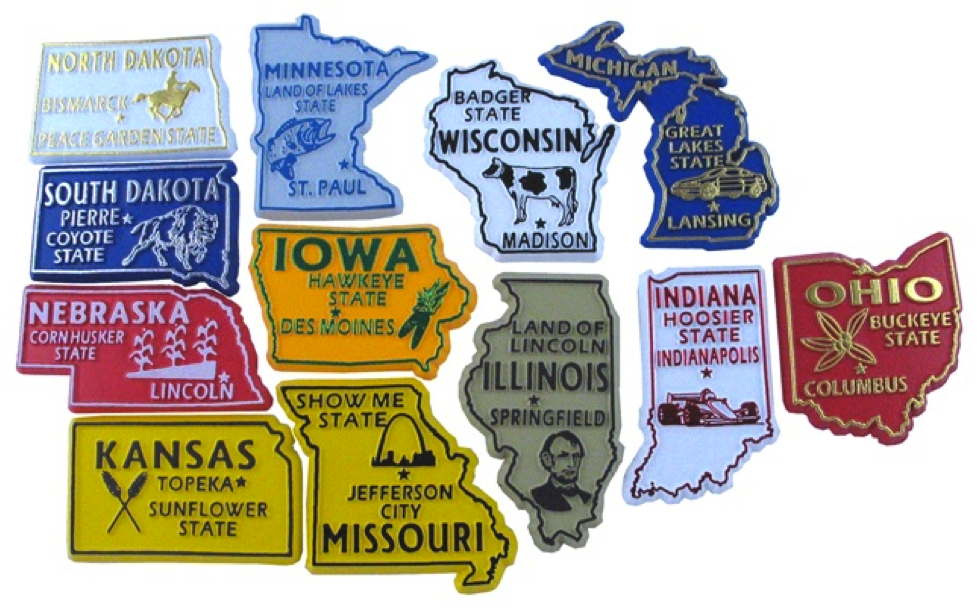
Midwest States and Nicknames
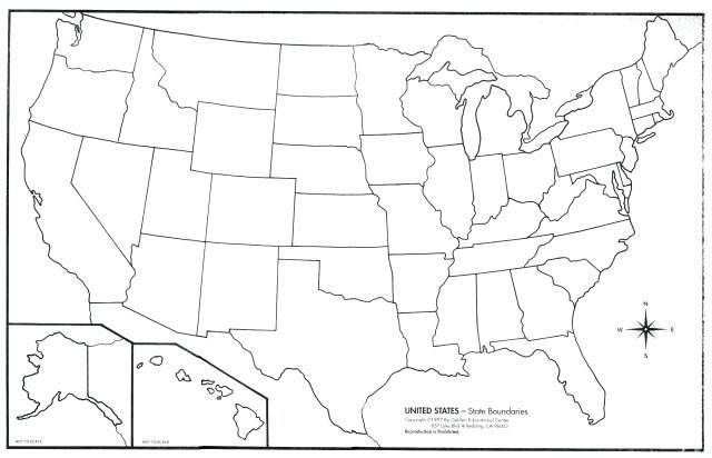
Preassessment Map
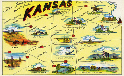
Postcard from Kansas (Notice illustration, nickname, greeting, major landmarks and tourist attractions)
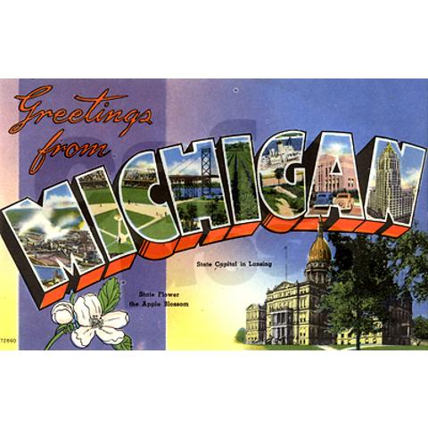
Notice the State Flower, Capital and information about bridges, lakes, baseball, architecture etc is included within the name.
